
Science & discovery
1513
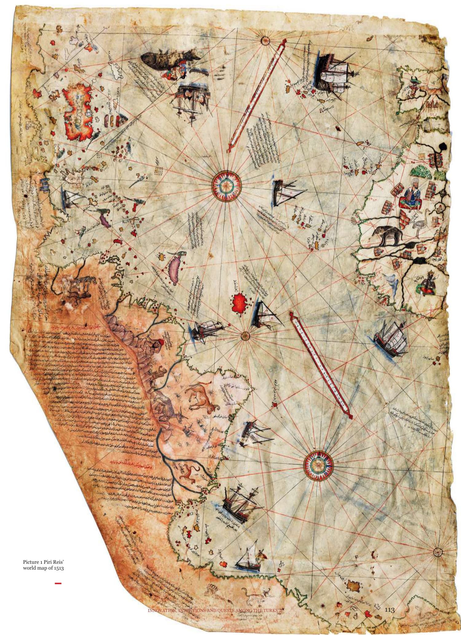
Piri Reis's “yappamondo” 1513 world map, which has been the source of controversy and various theories since its discovery in 1929
Piri Reis, born in Gelibolu, is believed to have been born around 1470, considering the years he spent with his uncle, Kemal Reis. According to his writings, he engaged in piracy with his uncle Kemal Reis, primarily targeting Venetian forts and shores, as well as conducting piracy throughout the entire Mediterranean. Later, he entered into state service. When Kemal Reis was summoned to state service by Sultan Bayezid II, Piri Reis likely accompanied him during his reception in İstanbul in 1495.
With the death of Kemal Reis in 1510, a new phase began in the life of Piri Reis. During Yavuz Sultan Selim's campaign to Egypt, Piri Reis, serving as the captain of a ship in the fleet under the command of Admiral Cafer Bey, presented the Sultan with his first world map in Cairo, reached through the Nile River, in 1513. In 1524, he served as a guide on the fleet of Grand Vizier Makbul İbrahim Pasha, who
traveled to Egypt by sea. During this time, he had the opportunity to meet closely with İbrahim Pasha, who reviewed the draft of the first Kitâbı Bahriye written by Piri Reis on the ship. He presented the second edition of Kitâb ı Bahriye in 1526 and the second world map in 1528 to Sultan Suleiman the Magnificent. Later, he joined the navy reestablished by Hayreddin Barbarossa (Barbaros Hayrettin Paşa).
Piri Reis, appointed to the position of captain of the Indian Ocean in 1547, succeeded Ferhad Pasha. His first mission in this role was to recapture Aden, the sole Ottoman base in the Indian Ocean. Piri Reis's second expedition targeted the Portuguese stronghold of Hormuz in the Persian Gulf. For this campaign, he set sail with a fleet of thirty ships, including galleys, galleons, and kalyons, departing from Suez in May 1552.
Piri Reis entered the Gulf of Oman and besieged Muscat. After a weeklong siege, he captured the fortress, taking 128 Portuguese soldiers as prisoners. Following this success, he marched towards Hormuz. With a fleet of twenty-eight ships and 850 soldiers, he laid siege to Portuguese-held Hormuz. While most of the island was taken, the inner fortress remained unconquered. Piri Reis decided to lift the siege and headed towards Basra.
Faced with the threat of the closure of the Persian Gulf by the Portuguese navy, Piri Reis left his main fleet in Basra and sailed to the Suez with three galleys. One of the ships ran aground and was wrecked on the way, leaving him with only two galleys to reach Suez. From there, he traveled by land to Cairo. However, upon arrival, he was not well received by the Governor of Egypt, Semiz Ali Pasha, and was perceived as a commander who abandoned his army on the battlefield. At that time, Sultan Suleiman the Magnificent was in Aleppo. Likely due to accusations, Piri Reis was probably killed in Egypt in late 1533. All his possessions and belongings were confiscated by the authorities in Egypt and sent to İstanbul.
Piri Reis gained great fame with his work titled Kitâbı Bahriye, which includes two world maps and a Mediterranean portolan94 chart. The fragment of the world map he drew in 1513 in Gallipoli shows Spain, Portugal, the West African coast, and the eastern coasts of the Americas. The sources of this significant map are ancient maps from the East and the West, as well as the map of Christopher Columbus. In Kitâbı Bahriye, Piri Reis mentions that he obtained information about the new maps of
the Indian and Chinese seas and presented these maps to Sultan Selim I. The map provides clues that suggest a careful tracking of new discoveries up to that time. In 1528, he drew a second world map showing the northern part of the Atlantic Ocean, as well as the coasts of North and Central America. Kitâbı Bahriye, serving as an atlas for the coasts of the Aegean and Mediterranean, was first presented in prose in 1521. The second version, revised and cleaned up, was partly in verse and presented to Sultan Suleiman in 1526. It became a guidebook that sailors did not part with, primarily based on Piri Reis's own observations. There are complete and partial translations of the work in various foreign languages.95
Piri Reis's map from 1513, of which we have a fragment, includes the coastlines of West Africa, the Azores, the Canary Islands, and Cape Verde Islands, encompassing both sides of the Atlantic Ocean. It also depicts the known parts of the Atlantic Ocean, South America, Central America, Florida, and the Antilles. In addition to the drawings, Piri Reis added various explanations to the map, including details about the places, when and by whom they were discovered, and the maps he consulted while drawing. The map contains depictions of various real and imaginary human and animal figures. Drawn in color on parchment, the map is divided into different regions, each accompanied by information about the region and illustrations of interesting animals and plants found there. Mountains, rivers, seas, sandy shallows of the seas, and unseen rocky parts of the seas have been depicted. The most noteworthy of these notes are those related to the discovery of America
Picture 1 Piri Reis’ world map of 1513
Picture 2 İstanbul in Kitâbı
Bahriye
and its coasts, for which we will provide the verbatim translation in the fifth section below.
The map has dimensions of 87 cm in height, 63 cm in the upper part, and 41 cm in the lower part. Unexplored areas are left blank on the map, and there are no latitude and longitude lines. Distances are determined using two large compass roses in the north and south, along with two distance scales arranged near the Cancer and Capricorn tropics. Additionally, the map features nine ship drawings and illustrations of cities, towers, animals, and indigenous peoples along the coasts and on land. Piri Reis states that he used 33 maps to create this map. Among them, 20 are old world maps, 8 are caferi maps drawn by the Abbasid Caliph Abu Ja'far al-Mansur, and 4 are Portuguese maps. One map belongs to Columbus, although his first map of America is lost. Therefore, Piri Reis's map is the only one drawn based on the first map of America available today.
Piri Reis drew another world map 15 years after his 1513 map. The piece of the map we have today shows Greenland and the coasts of North and Central America. Prepared in color on gazelle skin, this map has dimensions of 68x69 cm and is more meticulously drawn than the first map. It consists of a total of 8 sheets. The map features four compass roses and two mile scales, with the scale being larger than that of the first map. The presence of the Tropic of Cancer on this sheet suggests that the Tropic of Capricorn and the Equator are likely present on other sheets. It appears that Piri Reis, within the span of 15 years, followed all the new discoveries, corrected errors in his previous map, and filled in the blanks. In this
second map, Cuba and the Antilles, previously indicated as a continent in the first map, are now shown as islands.
When the two maps are compared, it is evident that they reflect the ongoing events worldwide. Piri Reis and, consequently, the Ottoman Empire were not isolated from the events in the Western world during that period, showcasing a clear awareness of developments in the West. Piri Reis's approach is a clear indication that the Ottoman Empire valued knowledge as a means to become a powerful state, emphasizing the importance of growth guided by information. From this perspective, Piri Reis's works stand out as both contemporary global endeavors and distinguished works of the 16th century. The discovery of the new continent initiated an exciting and novel period in the European intellectual world. Maritime geography became a heavily studied field. Piri Reis's works emerged contemporaneously with European endeavors and are remarkable for their equivalence in significance.
Kitâbı Bahriye, another work by Piri Reis, is a comprehensive sea atlas specifically designed for the Aegean and Mediterranean regions. Written in 1521, the book provides sailors with easy navigation through the maps it contains. Piri Reis states that he wrote this work to evaluate the experiences gained and information heard during the expeditions with Kemal Reis and his companions. The book includes detailed information about the Mediterranean, Red Sea, Indian Ocean, and the South China Sea, aiming to facilitate sailors' travels without the need for additional guidance.
In Piri Reis's map, the absence of latitude and longitude lines is noteworthy, and the scaled representation of the Earth is remarkable. Another point is his ability to reduce and compare maps of various scales to create a single comprehensive map. Piri Reis played a pioneering role in transitioning from cartography based on myths, dogmas, and unfounded beliefs to cartography grounded in observation, experience, and historical facts.
Additionally, the conquest of Egypt in 1517 and the subsequent Ottoman citizenship of Barbaros Hayreddin Pasha, the ruler of Algeria, ensured the establishment of Ottoman control in areas extending as far as Gibraltar. Before that time, the Ottoman Empire could only use its naval forces as a logistical and support element for the land army. One of the reasons the Ottoman State could suddenly transform into a strong and feared naval power was attributed to Piri Reis's cartography and seamanship. It is clear that for Mediterranean dominance, it was not enough to prepare only the navy; knowledge of each coastal corner's refuge, supply, and anchoring facilities was also essential. In Kitâbı Bahriye, Piri Reis provided strategic information about where the Ottoman navy could supply, where to take water, where to seek shelter from storms, and the conditions of the coasts and these places.96
The map dated 1513 by Piri Reis has consistently captured the attention of researchers. Despite his other works being as important as the 1513 map, more emphasis has been placed on the 1513 map. The examinations, research, and critiques conducted on this map can be summarized under three main headings, and furthermore,
there is no consensus on the results of these studies. The opinions on the construction and accuracy of the map can be summarized under three main headings:
The group of opinions suggesting that the map is accurate but not made by Piri Reis acknowledges that the map dated 1513 has scientific value that cannot be compared with the knowledge, technical capabilities, and conditions of the time it was created. However, according to them, it would have been impossible for such a map to be created in those years, especially by a Turkish seafarer. Therefore, they propose that the map might have been made by a very ancient civilization or extraterrestrial beings.
Addressing the topic within this perspective, Professor Charles Hapgood was the first to bring it to light by examining Piri Reis's map along with maps and geographical works from Europe and America. He announced his findings to the world in his book titled Maps of the Ancient Sea Kings. Hapgood based all his views on an ancient civilization that he believed existed 20,000 years before the Common Era, exerting great effort to attribute all the details and drawings on the 1513 map to this civilization. However, no evidence has been presented to support the existence of the ancient civilization upon which these views are based.
After Hapgood, in 1973, Erich Von Daniken also asserted, based on assumptions, in his book Chariots of the Gods that the map from 1513 was not made by Piri Reis. Statements like Piri Reis’s map was made by aliens' reflect assumptions without valid evidence and inadequate claims. The depiction of the
Picture 3 Jazair Castle in the
land of Maghrib in Kitâbı
Bahriye
coastlines of South America on Piri Reis's map remains unclear and continues to be a subject of various interpretations, with practical considerations leading to different perspectives.
According to the second view, when compared to other maps made during that period, the map is not of sufficient accuracy to warrant special attention, lacking important features and being considered an ordinary map.
According to the view led by Celal Şengör, Piri Reis, when he completed the first world map in 1513, was able to present it to the Sultan only during the conquest of Egypt in 1517 but could
not find any support. Later, he wrote Kitâbı Bahriye, but this exquisite and truly unparalleled Mediterranean portolan book, which was ahead of all its counterparts for its time, also did not receive the expected attention from Sultan Süleyman. There is no evidence that Piri Reis' world map, made in 1528 and of which only 1/6 remains today, attracted the slightest interest from the powerful Ottoman sultan of his time. On the contrary, Piri's intelligent and curious head fell to Egypt in 1554, thanks to another imprudent decision of Sultan Suleiman the Magnificent; to the lands where he had presented the first
world map with who knows what hopes to his father, Yavuz Sultan Selim.
The world map created by Piri Reis in 1513 is a map that does not rely on any rigid mathematical projection, uses rhumb lines instead of latitude and longitude lines like contemporary portolans, is largely based on European maps and geographical knowledge, yet was created without being equipped with the latest information of its time, making it a map lagging behind its era. Its great importance in the history of cartography stems from its preservation of the lines that Christopher Columbus might have drawn in 1495-1496.97
However, it should be noted that the proponents of the second view do not constitute a large group. On the other hand, Celal Şengör's approach reflects a problematic perspective rather than a scientifically neutral one that should be maintained. The argument that Piri Reis failed to attract the attention of both Yavuz Sultan Selim and Kanuni should be juxtaposed with the situation Columbus faced in Spain upon his return from the American expeditions. Columbus embarked on his final voyage in 1502, and in the days following his return to Spain in 1504, due to the envy of those who did not like him, he was stripped of his admiralship and all his rights, ending up in the alleys of poverty.98
The third view is that the map is a very accurate, valuable, and important work created under the conditions of that time.99
According to the history of cartography expert Gregory C. McIntosh, Piri Reis's map is a typical product of its time. Its most important feature is being the only map that has survived
and carries traces of Christopher Columbus's second voyage. Piri Reis's map is drawn in the tradition of portolan100 maps. Portolan maps are sea charts depicting the Black Sea, Aegean Sea, Mediterranean, and the Atlantic Ocean coasts of Europe. Rectangular and northoriented portolans are based on navigation calculations and magnetic compass navigation. Starting from the late 15th century, portolanstyle maps began to go beyond traditional European geography to depict the entire world. The graphic symbols, colors, and illustrations in Piri Reis's 1513 map show typical portolan features. For example, shallow areas are marked with red dots, and rocks and reefs are indicated with crosses. Ships sailing south towards India, records mentioning the discovery of the Azores and Cape Verde Islands, the illustration of the legendary Antillia Island, the medieval legend of Saint Brendan, and the illustration of the Whale legend in Northeast Africa, as well as many other elements found in Piri Reis's map, are typical features of portolan-style world maps of that time.
McIntosh notes that the imaginary animal depictions seen in the South American part of the map were never encountered in this geography before Piri Reis's map. These bizarre creatures drew their roots from medieval literature, generally depicted in Asia, Africa, and sometimes in the islands of the Indian Ocean. Known as Pliny's types, these imaginary animals do not appear in any maps showing South America until 1599. Did Piri follow maps that he claimed to have, showing these bizarre creatures in South America? Or was this positioning entirely his own? Were these imaginary animals also present in the
Picture 4 Crete Island in
Kitâbı Bahriye
lost eastern part of the map, depicting Asia and Africa? We do not know the answers to these questions.101
According to McIntosh once again, the 1513 Piri Reis map is one of the most beautiful, interesting, important, and mysterious maps that has survived from a crucial period of maritime exploration. The fact that it was made by Piri Reis makes it particularly significant.
The second reason for the map's importance is that it is one of the few world maps drawn on parchment that has survived from that period. Of the unknown number of maps made in the
thirty years following the discovery of America, only about a dozen were drawn on parchment large enough to be mounted on a wall. Piri Reis's map is important not only because it preserves copies of Columbus's map but also because it conveys the developing knowledge of the New World geography of its time.
The third reason provides an understanding of how a world map was compiled from various sources in the 16th century, shedding light on the world as Piri Reis knew it. Exotic peoples and animals, gold mines, and Portuguese maritime activities are reflected in his notes.
The fourth reason for the significance of the
1513 map is the depiction of the Southern Continent. This continent is sometimes shown surrounded by water, sometimes connected to Asia, and sometimes to America on maps from the 14th to the 18th century. The last reason for the importance of Piri Reis's 1513 map is its connection to Columbus, which excites scientists and the world the most.102
In 2002, British submarine commander Gavin Menzies added a new dimension to the debate with his book titled 1421: The Year China Discovered the World. Fuat Sezgin, during the times he did not subject this issue to special research, also believed that Piri Reis provided us with Christopher Columbus's lost map. According to Sezgin, research indicates that the Chinese fleets visited 36 countries in the Indian Ocean and its surroundings, reaching as far as Borneo and Timor to the south and Malindi to the southwest. There is no information in Chinese sources about the fleet crossing beyond the Indian Ocean.
In the early 16th century, three major maps emerged in the history of geography. One of them is the African map that appeared in Europe as soon as Vasco da Gama returned from his first voyage. Menzies rightly questions which cultural world, especially the eastern coasts of Africa, could have achieved this excellent map. He argues that this required knowledge of measuring the true degree of longitude, a knowledge not possessed by Europeans and Muslims, but only by the Chinese.
Menzies thus touches on one of the weakest aspects of cartographic historiography. Historians believe that this map was created in a few months with the information brought to
Portugal by Vasco da Gama, who went to Calicut in India with Muslim guides and returned. According to Sezgin, Menzies is right in his reaction that this map cannot be the work of the Portuguese, but his claim that the Chinese measured longitude degrees is contrary to the history of geography, astronomy, and navigation. Until the 18th century, the Chinese neither dealt with astronomical longitude degrees nor succeeded in creating a map based on astronomically measured longitude degrees. Neither Vasco da Gama nor other Portuguese sailors claimed to have drawn maps of the Indian Ocean or Africa, aside from a few sketches of the Red Sea, nor did they claim to have transported materials to Portugal for the creation of the map. On the contrary, they did not hesitate to explain that they took these maps from the hands of Muslim sailors. Geographical historians did not take this point into consideration. According to the prevailing belief, any innovation seen on world maps after the Greeks is considered the achievement of Europeans.
The world map bearing the name of Ptolemy shows oceans as enclosed seas surrounded by lands. In the world map commissioned by Caliph Al-Ma’mun in the early 9th century, the most significant innovation is the depiction of oceans as enclosed by lands and Africa in the form of a peninsula. About 320 years after this work by Abbasid scholars, we encounter a considerably advanced representation of North and Central Asia in the world map completed in 1154 by Idrisi. Following this, we witness further progress in world maps over approximately 300 years. Subsequently, in the 13th or 14th century, there is a high probability
Picture 5 Birindisi Castle and city in Kitâbı Bahriye
that a map of North and Central Asia, most likely created in Turkish, emerged in Siberia in the early 18th century along with Bahadir Khan's Tatar history. Unfortunately, this map, one of the most important documents in the history of cartography, has not been examined as it should have been. The coasts of Siberia, the latitudinal and longitudinal degrees of the rivers flowing into the Arctic Ocean, and the lakes of Central Asia are priceless documents showing how much progress the Asian map made in the Islamic cultural world. According to Sezgin, if Menzies had known this map, perhaps he would have been more careful in
his judgment.
Even in the early 9th century, Muslims, using advanced scientific methods, estimated the length of the equator to be around 40,000 km and believed that the ocean between Europe and Asia was degrees, making it impossible to cross. In the early 11th century, Biruni stated that the lands were surrounded by an ocean. In the first half of the 10th century, Mesudi, in one of his books that has reached us, repeats information about those who ventured westwards across the ocean, risking their lives: “Among them, there is a man named Haihas from Cordoba, who, with a
group of people, set sail into the ocean. After some time, they returned with great spoils. Others did not return. This is a well known fact in Andalusia.”
Christopher Columbus's contemporary and the author of Historia de las Indias, Bartolomé de las Casas, provides interesting information about the history of Columbus's voyages. In his book, the famous historian, whose father participated in Columbus’s expeditions, repeatedly mentions that Columbus had an old map in his possession. He explains that this map later came into his own hands and was, in fact, sent to Columbus by the Florentine Toscanelli. In one particularly interesting piece of information, Casas states that Columbus and other captains always relied on this map. At one point, Captain Alonzo Pinzon took the map with him a few islands away. Columbus sent him a message to return the map for planning the next route. After the map was returned, Columbus, along with other sailors, conducted position assessments.
Casas inadvertently reveals that this map (mistakenly) depicts the (presumed) location of the Indian coast and islands. All this, along with other information, unequivocally indicates that Columbus set out with a highly detailed map to reach a known country. Some information also suggests that the goal was not to discover a new place but to bring back gold, precious stones, and spices from known locations.
Piri Reis states in a note added to his map that Columbus set sail with a book that came into his hands. Now, the fundamental problem hinges on the answer to this question: Which cultural world were the maps that fell into the
hands of Columbus and the Portuguese a product of?
In the year 1500, the map of Juan de la Cosa, who served as captain on one of Columbus's first three voyages, indicates that a chart originating from a culture adept at accurately measuring longitudinal degrees was in the possession of the Spaniards. South America is visible on this map before the Portuguese discovery. A significant connection between this map and Piri Reis's becomes evident. When we compare Piri Reis's map with a modern map using computer assistance, it is observed that the coastlines of South America are depicted quite accurately, to some extent, well into the interior. The longitudinal degrees between Africa and Europe achieved an accuracy only possible in European cartography in the 18th and 19th centuries. In the 15th and 16th centuries, no other cultural sphere, except the Islamic world with its advanced methods in Indian Ocean navigation, could achieve such precision. It is claimed that Columbus measured some latitude and longitude degrees towards the coasts of America. However, these values are erroneous, ranging from 22 to 40 degrees inaccuracy, or more precisely, they are more fanciful than actual measurements.
In 1933, the erudite German scholar Paul E. Kahle subjected Piri Reis's map to a meticulous inquiry, leading to the inference that the cartography in question must have derived from an original possessing defined longitudinal and latitudinal coordinates. Kahle postulated that this original, alleged to have been dispatched to Columbus by Paolo Toscanelli of Florence in 1474, served as the
foundational source. However, the intricacies of its genesis and provenance were left unexplored. Kahle contended that the segment pertaining to Central America found its way to Piri Reis via Columbus while positing that the South American portion was appended by Piri Reis himself, drawing upon Portuguese cartographic sources. The outcome of Kahle's investigation has propagated the prevalent belief in subsequent scholarly endeavors that the map bearing Columbus's annotations was procured from an individual who partook in Columbus's tripartite expeditions, amidst the captives seized in 1501 by Kemal Reis aboard a Spanish vessel. According to Fuat Sezgin, Piri Reis came into possession of an Arabic map originating from the Islamic cultural sphere through Italians, depicting longitudinal and latitudinal lines with certain additions made by Columbus. Presumably, various copies of this map were in circulation. This map significantly differs from the rudimentary chart produced by Columbus for his brother, presented to the palace upon insistent demand from the Spanish throne after Columbus's third voyage. The inaccurately drawn map of Cuba, most likely belonging to Columbus and his associates, stands in stark contrast. It can be speculated that the piece of land to the south on the map had its origins in the Arabic original that reached Italians.
In summary, according to Sezgin, the human discovery of the continent later known as America occurred in three stages:
1. People, since an age with an unknown origin, intermittently reached the vast landmass within the ocean through occasional happenstance. This is a widely accepted fact
even in contemporary times.
2. Muslims, starting from at least the first half of the 10th century, endeavored to sail westward to the opposite shore of the ocean from the Iberian Peninsula and the western coasts of Africa, a number of times whose exact count remains uncertain. They had been reaching the same shores from the southern part of Africa since the 9th century. Their attempts to sail westward across the ocean must have reached the great landmass at an unknown date for us but no later than the early 15th century, and they likely repeated this feat numerous times. As members of a cultural sphere that advanced mathematics, geography, and cartography for 800 years from the 9th century, they crafted maps of the western Atlantic and coastlines. However, starting from the 16th century, like in other fields of science, they experienced a historical destiny of losing their leading positions and yielding their place to others.
3. Just as Bartolomeo Diaz and Vasco da Gama were oriented towards the Cape of Good Hope and the Indian Ocean with the maps of the Muslims, Columbus and Portuguese navigators, including Magellan, reached America with maps from the Islamic world that came into their hands. Neither the early Portuguese nor the Spanish concealed this reality. They diligently and industriously developed the task inherited from Muslim pioneers. We owe the revelation of the existence of a new continent to them.103
The fifth annotation found on Piri Reis's map in 1513
This section (chapter) declares the presence of
Picture 6 Piri Reis's 1513 world map, fifth chapter notes and
pictures
these coasts and islands.
These coasts are called the shores of Antalya. It was discovered in the year 896 of the Arab calendar. However, they narrate that a disbeliever from Genoa, named Columbus, found these places. For instance, it is recounted that the aforementioned Columbus came across a book that had reached him, stating the extremity of the Maghreb (West) Sea, which includes coasts and islands on the western side and various types of minerals and the mountain of jewels. After thoroughly perusing this book, Columbus explained these discoveries to the notables of Genoa, elucidating each circumstance, and said, “Come, give me two ships, let me find these
places.” They responded, “O confused mind, the limit, end, and boundary of the Maghreb
Sea are known? It is filled with darkness, they say.”
Columbus, realizing that there was no solution from the Genoese, persisted. He reached the Spanish Sovereign, presented his narrative, and received a similar response as from the Genoese. In conclusion, Columbus insisted on them, and, in the end, the Spanish Sovereign provided him with two ships, armed and equipped, saying, “O Columbus, if what you say is true, go and conquer that land,” sending Columbus to the Western Sea.
The late Gazi Kemal had a Spanish servant, and this servant informed Gazi Kemal three
times that he had reached that land with Columbus. He recounted to the late Kemal Reis, saying: “First, we reached the Strait of Gibraltar, then from there, we continued to the middle of the setting sun and the southwest... after walking four thousand miles, we saw an island in front of us. However, as we approached, the waves of the sea, called the foam, had disappeared, indicating that the sea had calmed and become smooth. The North Star, also known as the star of sailors in their compasses, had vanished as we progressed; and he said that these arranged stars are not visible in that land, and the other stars are visible in a different arrangement.”
Before that, they anchored to the island they saw, and the people of that island came, shooting arrows at them, preventing them from going ashore to inquire. Both men and women shot arrows from bows made of fish bones. The tips of the arrows were made of fish spines, and they all walked on all fours… They realized that they could not disembark on that island, so they went to the other side of the island and saw a boat; when they approached, the boat capsized. They tried to retrieve the boat, and they found that it contained human flesh. It turned out that these people were pirates who went from island to island, capturing and eating people.
Columbus saw another island and arrived there, seeing that there were large snakes on the island. Hesitating with fear, they reached yet another island. Anchoring there, they spent seventeen days. The people of this island saw that there was no harm from this ship, so they approached, catching fish with a special type of net and bringing them to the ship. They were pleased and offered glass beads to them. It
turned out that glass beads were considered valuable in that land, as found in an authentic book. When they saw the beads, they brought even more fish. They continued to give glass beads to them every time. One day, they saw gold in the arm of one of them. They took the gold and offered beads in return. They said, “Come, bring more gold, and we will give you more beads.” They went and brought plenty of gold. It turned out that there was a gold mine in the mountains of that land. One day, they saw pearls in the hand of one of them. They took the pearls and gave beads in return. When they saw that they were giving beads, they brought more pearls. It turned out that pearls were found in the shallows of that land, and they loaded the ship with valuable wood from that land, taking two of the people from that land and bringing them to Spain within that year.
However, Columbus communicated with these people using sign language as they did not know their language. After this expedition, the Spanish Sovereign sent priests and wheat to teach them farming and initiated their own way of life. They assimilated these people's faith and customs, walking and lying like animals. Now, these lands have opened up and become well known. The names of these places found in these islands and coasts are known through Columbus. Columbus was also a great astrologer. The coasts and islands mentioned on this map are written based on Columbus's map.104
Source: Innovation, Inventions and Quests Among the Turks